Few holiday questions carry as much emotional sparkle as this one: Will there be snow on Christmas Day? It is the weather version of shaking a wrapped gift under the tree. You know you probably should not get too excited, but you do it anyway. A white Christmas can make even a regular front porch look like a greeting card, while a rainy Christmas can make the inflatable Santa in the yard look as if he has just survived a very difficult commute.
The Farmer’s Almanac and Old Farmer’s Almanac have long been part of America’s winter-weather conversation, especially for people planning holiday travel, family gatherings, ski trips, and festive backyard photos. Their long-range forecasts are not the same as a precise local forecast from the National Weather Service, but they can give readers a seasonal sense of where cold, snow, rain, and messy travel may be more likely.
So, will your region wake up to snow on Christmas morning? The honest answer is: it depends on where you live, how cold the air is, whether storms arrive at the right time, and whether snow already on the ground survives until December 25. Let’s break down what the Almanac-style outlook suggests by region, what counts as a true white Christmas, and how to read the forecast without turning your holiday plans into a meteorological guessing game.
What Counts as a White Christmas?
In the United States, a white Christmas generally means there is at least 1 inch of snow on the ground on Christmas morning. This is important because it does not necessarily mean snow has to fall on December 25. If a storm drops several inches on December 22 and cold air keeps it from melting, congratulations: you may still have a white Christmas, even if Christmas Day itself is sunny.
This definition surprises many people. Hollywood has trained us to expect gentle flakes floating past the window while someone carries cocoa in a cable-knit sweater. Real weather is less theatrical. Sometimes the snow arrives early, sometimes it turns to slush, and sometimes the atmosphere decides that freezing rain is the holiday special no one ordered.
That is why snow depth, not just snowfall, matters. A city can see snow during Christmas week and still miss out on a white Christmas if temperatures rise above freezing and melt the snowpack. On the other hand, colder northern towns may keep snow on the ground for weeks, making a white Christmas far more likely even without a fresh storm.
What the Farmer’s Almanac Says About Christmas Snow
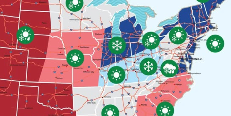
The most recent Almanac Christmas outlook pointed to better snow chances across several traditionally wintry regions, including the Northeast, Upper Midwest, Lower Lakes, eastern Ohio Valley, and Alaska. These are places where cold air, storm tracks, lake-effect snow, or existing snow cover often work together to keep the Christmas dream alive.
The outlook also suggested more mixed conditions in the Pacific Northwest, Intermountain West, High Plains, and parts of the South. In those regions, elevation makes a huge difference. A mountain town may see a postcard-perfect snowy morning while a nearby valley gets rain, fog, or the kind of chilly drizzle that makes everyone suddenly appreciate indoor hobbies.
One key takeaway: a regional forecast is a broad brush, not a street-level answer. “Snow in the Northeast” does not mean every backyard from Maine to New Jersey will be frosted like a gingerbread house. Coastal areas, major cities, and lower elevations often have much lower odds than inland hills, lake-effect belts, and mountain communities.
Regional Snow Outlook: Where Christmas Snow Looks Most Likely
Northeast: Strong White Christmas Potential, Especially Inland
The Northeast is one of the classic white Christmas regions, but it is not equal from one town to the next. Northern New England, upstate New York, interior Maine, Vermont, and New Hampshire usually have better odds than coastal cities such as New York City, Boston, or Providence. Elevation and distance from the ocean matter because milder marine air can turn snow into rain near the coast.
According to the Almanac-style outlook, parts of the Northeast had a strong chance of cold and snow around the holiday period. That means travelers heading through the Adirondacks, Green Mountains, White Mountains, or interior New England should plan for winter roads. Meanwhile, big coastal cities should keep expectations realistic. A festive flurry is possible, but a guaranteed snow globe scene is not.
Upper Midwest: A Reliable Contender for Christmas Snow
If the white Christmas competition had a varsity team, the Upper Midwest would be wearing the captain’s jacket. Minnesota, Wisconsin, northern Michigan, the Dakotas, and parts of Iowa regularly have colder December weather and better snow-cover odds than much of the country. Places near Lake Superior and Lake Michigan can also benefit from lake-effect snow, which can pile up quickly when cold air passes over warmer lake water.
The Almanac outlook highlighted the Upper Midwest as one of the regions with meaningful Christmas snow potential. That does not mean every neighborhood will see fresh flakes on December 25, but it does mean snow already on the ground has a better chance of sticking around. In cities such as Duluth, Marquette, Green Bay, and Minneapolis, a white Christmas is much more realistic than in warmer central or southern states.
Lower Lakes: Lake-Effect Snow Can Change Everything
The Lower Lakes region includes areas around the Great Lakes, such as parts of Illinois, Indiana, Ohio, Michigan, Pennsylvania, and western New York. This is one of the trickiest regions to forecast because lake-effect snow can be highly localized. One town may receive several inches while another town 20 miles away sees only clouds and complaints.
The Almanac outlook suggested that the Lower Lakes could be one of the better regions for Christmas snow. That is especially true for places downwind of the lakes, including parts of western New York, northeast Ohio, northwest Pennsylvania, and western Michigan. Still, timing is everything. If cold air arrives after the moisture leaves, the region may simply get dry cold. If moisture arrives with marginal temperatures, snow can turn into rain or slush.
Eastern Ohio Valley and Appalachians: Snow Chances Rise With Elevation
The eastern Ohio Valley and Appalachian region can deliver beautiful Christmas snow, especially in the higher terrain of West Virginia, western Pennsylvania, eastern Kentucky, and the mountains of Virginia, Tennessee, and North Carolina. Lower-elevation cities may face more uncertainty, with rain, wet snow, or a cold but snow-free morning all possible.
Almanac guidance pointed toward some wintry potential in the eastern Ohio Valley, which makes sense because this region often sits near the battleground between cold northern air and milder southern moisture. When the storm track lines up correctly, the result can be a memorable Christmas snow. When it does not, the result may be gray skies and everyone pretending the fireplace video on the TV counts as atmosphere.
Alaska: The White Christmas Heavyweight
For much of Alaska, the question is not “Will there be snow?” but “How much snow will be on the ground?” Many Alaskan communities have extremely high odds of snow cover by late December because temperatures are cold enough to preserve snowpack. The Almanac outlook included Alaska among the regions with strong winter conditions around Christmas.
Of course, Alaska is enormous, and coastal areas can be more variable than interior locations. Anchorage, Fairbanks, and inland communities often have much better white Christmas odds than places influenced by milder maritime air. Still, compared with most of the Lower 48, Alaska remains one of the safest bets for holiday snow.
Regions With More Uncertain Christmas Snow
Pacific Northwest: Rain Below, Snow Above
The Pacific Northwest is a classic elevation story. Seattle and Portland are more likely to see rain than snow at Christmas, while the Cascades can look like a winter fantasy novel. The Almanac outlook suggested stormy conditions in parts of the northern Pacific Northwest, but whether that means rain or snow depends heavily on temperature and altitude.
For holiday travelers, the mountain passes matter most. A lowland rainstorm may be a major snow event at higher elevations, creating chain requirements, delays, and white-knuckle driving. If your Christmas plan includes crossing the Cascades, checking short-term forecasts is not optional; it is the grown-up version of putting batteries in the toy before wrapping it.
Intermountain West and Rockies: Mountain Snow Is the Main Event
The Intermountain West and Rockies have some of the best Christmas snow scenery in the country, especially in higher-elevation parts of Colorado, Utah, Wyoming, Montana, Idaho, and northern New Mexico. Ski towns and mountain communities often have far better odds than nearby desert valleys.
The Almanac outlook suggested rain and snow showers in parts of the Intermountain West and High Plains. In practical terms, that means travelers should watch elevation, storm timing, and road conditions. Denver, Salt Lake City, and Boise may have mixed odds depending on the pattern, while higher mountain locations can hold snow much more reliably.
High Plains: Big Swings, Big Surprises
The High Plains can go from mild and windy to icy and dramatic faster than a relative changing the subject at Christmas dinner. Parts of Nebraska, Kansas, eastern Colorado, eastern Wyoming, and the Dakotas can see snow, but strong winds and temperature swings often complicate the picture.
A white Christmas here may depend on whether a storm system arrives close enough to the holiday and whether cold air stays in place afterward. Snow can fall and then disappear quickly if sunshine, wind, or above-freezing temperatures return. In this region, historical odds are useful, but the final forecast in the week before Christmas is especially important.
The South: Rare, Magical, and Usually Not a Safe Bet
Across much of the South, a white Christmas is rare. Cities such as Atlanta, Dallas, Birmingham, New Orleans, and Charleston usually have low historical odds because December temperatures are often too warm for lasting snow. That said, “rare” does not mean “impossible.” Southern snow events do happen, and when they happen near Christmas, they become local legend almost immediately.
The Almanac outlook hinted at occasional wintry surprises in parts of the Southeast or southern Appalachians, especially where cold air can settle into higher elevations. Still, for most Southern readers, the better Christmas plan is to enjoy the lights, the food, and the freedom from shoveling. If snow arrives, treat it like a bonus gift from the atmosphere, not something you put on the family schedule.
Why Your Region’s White Christmas Odds Can Change Fast
Long-range forecasts are helpful for spotting broad patterns, but Christmas weather can change quickly. A storm track shifting 100 miles can be the difference between snow, sleet, rain, or absolutely nothing. Temperature is just as important as moisture. If the air near the ground is above freezing, falling snow may melt on contact or turn into slush. If the ground is warm from a mild December, early snowfall may not last.
Snowpack is another key factor. Regions that build snow cover earlier in December have a better chance of keeping it until Christmas if temperatures remain cold. This is why northern states, mountain towns, and lake-effect belts often outperform places that rely on a single perfectly timed Christmas Eve storm.
Urban heat also matters. Large cities tend to be warmer than surrounding rural areas because roads, buildings, and pavement absorb and hold heat. That can reduce snow accumulation or speed up melting. In other words, a suburb 40 miles inland may wake up white while downtown wakes up damp and deeply jealous.
How to Use the Almanac Forecast Without Overplanning
The smartest way to use the Farmer’s Almanac is as a seasonal planning tool, not a final travel forecast. If your region is highlighted for snow or cold, prepare for winter conditions. If your region is expected to be mild, do not completely ignore winter weather, but you can lower your expectations for a snowy movie-scene morning.
For real decisions, such as flights, road trips, outdoor events, and mountain travel, check your local National Weather Service forecast within seven days of Christmas. That is when short-range models become much more useful for timing, precipitation type, road impacts, and snowfall amounts.
Think of the Almanac as the early holiday whisper and your local forecast as the final RSVP. One tells you what kind of season may be shaping up. The other tells you whether you should pack boots, leave early, salt the steps, or accept that your Christmas will be more “wet pavement” than “winter wonderland.”
Practical Tips for a Snowy Christmas Day
If your region has a decent chance of snow, a little preparation can save a lot of holiday stress. Keep a snow shovel, ice melt, windshield scraper, and warm gloves ready before Christmas week. If you are driving, check tire pressure, fill the gas tank, and keep blankets, snacks, water, and phone chargers in the car. Nobody wants their Christmas story to include being stuck on the shoulder with a fruitcake and 3% battery.
For homeowners, clear walkways early and often if snow begins falling. Wet snow can become heavy, and packed snow can turn icy overnight. If guests are visiting, make sure steps, porches, and driveways are safe. A white Christmas is charming; Aunt Linda sliding across the walkway like a curling stone is less charming.
For travelers, build extra time into the schedule. Airport delays often ripple across the country when winter weather hits major hubs. Drivers should check road conditions before leaving and avoid mountain passes during the worst of a storm if possible. Christmas plans are special, but safety still gets the front seat.
Experience-Based Holiday Snow Stories and Lessons
Ask people what they remember about a white Christmas, and the answers usually have less to do with exact snowfall totals and more to do with atmosphere. A few inches on the lawn can make a familiar street feel brand-new. The usual morning noise is softer. Tire tracks curve through the neighborhood. Dogs leap into snowbanks with the confidence of Olympic athletes and the coordination of tossed laundry. Even adults who claim to be “over winter” often pause at the window a little longer than usual.
For families in northern states, Christmas snow can feel like part of the tradition. Children look for footprints near the porch and wonder if they belong to Santa, a parent, or the very suspicious delivery driver who came by on Christmas Eve. Grandparents compare the morning to winters from decades ago, usually with phrases like “real snow” and “back when winter meant business.” Someone inevitably says the roads were worse in the old days, and everyone nods because arguing with holiday nostalgia is a losing sport.
In mountain towns, snow can shape the entire rhythm of Christmas. People wake early to shovel, warm the car, and check whether the roads are passable before heading to family breakfast. Ski areas may buzz with visitors hoping for fresh powder, while local residents quietly hope guests remember how to drive in snow. The beauty is undeniable, but so is the work. Snow on Christmas is magical until it blocks the driveway, at which point the magic requires a shovel and lower-back flexibility.
In Southern cities, a Christmas snow event becomes a community memory. Because it is so rare, even a light coating can send people outside in pajamas and winter coats that still have store tags from three years ago. Kids scrape snow from cars to build tiny snowmen. Neighbors take photos of mailboxes, palm trees, porch railings, and anything else brave enough to hold half an inch of frozen wonder. The snow may melt by lunch, but the story lasts for years.
Travelers often experience the practical side of Christmas snow first. A snowy scene outside the cabin window is lovely; a snowy interstate at dusk is less poetic. Many people learn the same lesson the hard way: check the forecast before leaving, not after the windshield wipers start fighting for their lives. Flexible plans, earlier departures, and backup lodging can turn a stressful holiday storm into a manageable delay.
The best white Christmas experiences usually come from balancing wonder with preparation. Enjoy the quiet streets, the glittering trees, the snow-covered rooftops, and the feeling that the world has briefly agreed to look festive. But also clear the steps, watch the roads, dress warmly, and keep expectations realistic. Snow is beautiful, but it is still weather. It does not care that you planned matching family outfits.
Final Verdict: Will Your Region See Snow on Christmas Day?
If you live in the Northeast, Upper Midwest, Lower Lakes, eastern Ohio Valley, Alaska, or a high-elevation mountain region, your odds are generally stronger than average. If you live along the West Coast lowlands, the Deep South, the Gulf Coast, or much of the Southeast, snow is far less likely, though not impossible. The Pacific Northwest, Rockies, Intermountain West, and High Plains depend heavily on elevation, storm timing, and temperature swings.
The Farmer’s Almanac can give you a useful regional clue, but the final answer comes from local conditions in the days before Christmas. Snow needs the right combination of cold air, moisture, timing, and staying power. When those ingredients line up, Christmas morning can look like a holiday card. When they do not, there is always hot chocolate, cozy lights, and the comforting knowledge that nobody has to shovel rain.
Note: This article is based on publicly available Almanac-style regional outlooks, NOAA/NWS white Christmas definitions, historical climate-normal guidance, and general U.S. winter-weather patterns. For exact Christmas travel and safety decisions, readers should check their local forecast during Christmas week.