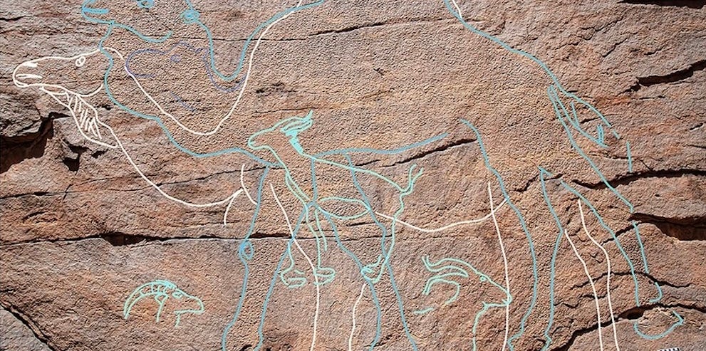
At first glance, the sandstone cliffs south of Saudi Arabia’s Nefud Desert appear to offer the usual desert package: rock, sand, punishing sunlight, and absolutely no complimentary beverage service. Look more carefully, however, and enormous camels, gazelles, ibex, wild equids, and other animals begin to emerge from the stone.
These ancient engravings are not merely attractive examples of prehistoric rock art. Dating evidence associated with the sites indicates that people occupied this demanding landscape between approximately 12,800 and 11,400 years ago, during the transition from the Pleistocene to the Holocene. That places human communities in northern Arabia about 2,000 years earlier than many archaeologists previously expected for this particular period.
The findings do not prove that every established theory of human migration should be thrown into a scholarly recycling bin. They do, however, fill an important gap in Arabia’s archaeological record and challenge the idea that the region’s interior was simply abandoned after the Last Glacial Maximum. Instead, the desert may have contained seasonal migration corridors connected by temporary lakes, rock pools, animal movements, and generations of carefully preserved environmental knowledge.
A Monumental Discovery in Northern Arabia
The engravings were documented at several locations in the Sahout region of northern Saudi Arabia, including Jebel Arnaan and Jebel Misma. Researchers recorded more than 170 engraved figures and partial images at newly investigated localities. Across the broader research area, approximately 130 life-size animal images have been identified.
Wild camels dominate the collection, but they are not alone. The sandstone also carries images of ibex, gazelles, wild equids, human figures, and an aurochs, the extinct wild ancestor of domestic cattle. Some animals are close to life-size, while several camels measure more than six feet tall. One panel was placed high on a cliff, where ancient artists apparently worked from a narrow ledge without enough room to step backward and inspect the entire image.
That is impressive under any circumstances. Try drawing a reasonably accurate camel while standing on a sloping ledge with stone tools and no eraser. Most modern people would produce something resembling an angry coat hanger.
Rock Art That Appears and Disappears
Some of the carvings are so weathered that they become clearly visible only when low morning sunlight strikes the rock at the correct angle. For a brief period, shadows sharpen the engraved lines and reveal animals that seem to vanish again as the sun rises.
This limited visibility helps explain why the panels remained undocumented for so long. It also shows the importance of local knowledge. Members of the public and amateur archaeology enthusiasts alerted heritage authorities to several locations, helping professional researchers find sites that ordinary surveys might easily have missed.
How Scientists Estimated the Age of the Desert Etchings
Dating rock art is notoriously difficult. A carved line does not conveniently arrive with a manufacturing date stamped underneath it. Researchers therefore examined archaeological deposits, buried sections of engravings, stone tools, hearths, animal bones, and surrounding sediments.
At Jebel Arnaan, sediment had accumulated over the lower portions of an animal engraving. Excavation exposed both the hidden lines and a stone pecking tool capable of cutting sandstone. Luminescence dating helped determine when surrounding mineral grains were last exposed to sunlight or intense heat, while radiocarbon analysis was applied to suitable organic remains.
Together, the evidence placed the principal occupation between about 12,800 and 11,400 years ago. The association between the archaeological layers, engraving tool, and buried artwork provided an unusually strong chronological framework for a form of art that normally resists direct dating.
Older Images May Still Be Hiding in Plain Sight
The monumental animals were not necessarily the first images carved into these cliffs. Researchers identified earlier stylized human figures beneath some of the large animal engravings. Because the camel images overlap them, those human figures may be older than 12,000 years.
Later artists also returned to refresh or modify certain animals. This repeated engraving suggests that the panels remained culturally meaningful over long periods. They were not forgotten doodles. They were maintained, revisited, and incorporated into the memories of mobile communities.
The Desert Was Dry, but It Was Not Lifeless
During the Last Glacial Maximum, roughly 25,000 to 20,000 years ago, northern Arabia experienced extreme aridity. Wind-blown dunes expanded, dependable water became scarce, and evidence of human occupation largely disappears from the known archaeological record.
Conditions began changing before the Holocene. Geological evidence indicates that shallow seasonal water bodies, known as playas, developed in parts of the Nefud region between about 16,000 and 13,000 years ago. This was not yet the fully developed “Green Arabia” landscape associated with later humid periods. The lakes were temporary, rainfall remained limited, and survival still required considerable planning.
Nevertheless, temporary water can transform a desert. Rain-filled depressions attract animals, plants, hunters, toolmakers, and families. A chain of seasonal lakes may have created a usable route through terrain that otherwise looked like a wall of sand.
Following Water Instead of Imaginary Map Lines
The distribution of the rock art is especially revealing. At Jebel Misma, panels were positioned near the edge of an ancient seasonal lake. At Jebel Arnaan, the engravings follow a gully where water can still pool after rare rainstorms. That gully also offers a route across the mountain toward additional paleolakes.
The carvings may therefore have functioned as markers within a larger system of movement. They could have identified water sources, signaled access routes, reinforced territorial claims, commemorated successful journeys, or asked for the return of rain. Several purposes may have operated at once.
Calling the panels prehistoric road signs would be too simple, but the comparison is useful. They may have combined practical information, group identity, storytelling, and spiritual meaning. Think of a highway marker, community mural, family archive, and weather prayer carved into one enormous camel.
Why Camels Were the Perfect Desert Symbol
Camels account for most identifiable animals in the monumental engravings. This was long before camel domestication, so the artists were depicting wild animals whose seasonal behavior they knew well.
Several male camels appear to be in rut, with muscular necks and physical features associated with the mating season. In modern wild and feral camel populations, that season is connected with cooler, wetter months. The images may therefore encode a seasonal message: when camels behave this way, rain and temporary water are more likely to be available.
Animals may have acted as moving environmental indicators. Hunter-gatherers could observe where herds traveled, when they gathered, and how their physical condition changed. In a landscape without weather apps, reservoir maps, or roadside convenience stores, a camel herd was a useful source of information. It was essentially GPS with hooves.
The single aurochs engraving raises another question. Aurochs required more regular access to water than desert-adapted camels or ibex. The artist may have seen the animal during an unusually wet season, encountered it while traveling in a wetter region, or learned about it through contact with another community. Any of those possibilities points toward movement and communication beyond one isolated valley.
What the Engravings Reveal About Human Migration
Arabia occupies a crucial geographic position between Africa and Eurasia. For decades, researchers have examined whether its rivers, lakes, grasslands, and coastlines periodically helped human populations move between continents.
Older discoveries already demonstrate that people entered Arabia during multiple humid phases. Human footprints at the Alathar paleolake indicate that Homo sapiens crossed northern Arabia roughly 120,000 years ago. Stone tools from still earlier periods show that other human populations also entered the peninsula when rainfall turned parts of the desert into grassland and freshwater habitat.
The newly dated engravings concern a much later chapter. They reveal how hunter-gatherers returned to or expanded through northern Arabia near the end of the last ice age, when conditions were improving but remained harsh. These communities did not wait for the desert to become a lush paradise. They learned to survive with temporary water, high mobility, and detailed knowledge of animal behavior.
A Correction, Not a Complete Replacement
The discovery should not be interpreted as proof of a previously unknown mass migration out of Africa. It does not establish the ancestry of every later population, nor does it identify one definitive route used by all humans.
Its importance is more precise. Archaeologists previously lacked securely dated sites in northern Arabia between the Last Glacial Maximum and approximately 10,000 years ago. The new evidence narrows that gap and shows that people occupied the desert interior earlier than expected.
Human migration was probably not a single heroic march across a blank map. It was a series of expansions, retreats, local adaptations, reunions, and cultural exchanges. Groups moved when water and vegetation permitted, stayed when resources remained dependable, and withdrew when conditions deteriorated. The Arabian Peninsula was not merely empty space between Africa and Asia; it was a dynamic landscape with its own communities and histories.
Connections With the Levantand a Distinct Arabian Identity
Artifacts recovered near the engravings include stone projectile points, bladelets, beads, pigment-related materials, and other objects that resemble traditions known from the Levant, more than 250 miles to the north. These similarities indicate repeated contact across considerable distances.
Contact does not necessarily mean that northern Arabian communities were simple extensions of Levantine societies. The desert engravers adopted or exchanged certain technologies while developing their own monumental artistic tradition. Their culture was connected, but it was not copied and pasted.
This distinction matters because migration is not only the movement of bodies. It also involves tools, artistic ideas, symbols, social practices, and environmental knowledge. A projectile-point design can travel between communities even when most people remain close to home. A bead can move through several exchanges. A carved camel can express a local identity while incorporating techniques learned elsewhere.
The sites therefore present northern Arabia as an interconnected cultural landscape. People were mobile enough to maintain distant relationships yet rooted enough to create symbols specific to their desert environment.
Rock Art as a Map of Memory
Modern maps represent landscapes from above. Mobile hunter-gatherers experienced them as sequences: a shaded cliff after a morning walk, a gully that held rainwater, an animal trail across a ridge, and a lake basin reached before sunset.
The engravings may have organized that sequence into shared memory. A monumental camel could remind travelers where to turn, confirm that they had reached familiar territory, or preserve knowledge for younger generations. Repeatedly reworking the same panel may have renewed the community’s relationship with a place.
Such interpretations remain hypotheses, but the physical arrangement of the panels makes a purely decorative explanation unlikely. The images cluster around routes, gullies, and water sources. Their creators invested substantial labor in locations that mattered for both survival and identity.
In that sense, the desert was not empty. It was crowded with names, stories, routes, warnings, and expectationsmost of which are invisible to anyone who does not know how to read the landscape.
Why This Discovery Matters Today
The people who made these engravings lived with climate instability. Rainfall altered their mobility, influenced animal distribution, and determined which areas could support human life. Their response was not passive. They monitored seasonal signals, maintained long-distance contacts, and created durable systems for sharing knowledge.
That does not make prehistoric rock art a modern climate policy manual. Ancient communities were much smaller, used different technologies, and faced environmental pressures on another scale. Still, their achievements demonstrate the flexibility of human societiesand the limits of that flexibility when dependable water disappears.
The discovery also reminds researchers to be cautious about archaeological silence. A lack of known sites does not always mean a lack of people. Evidence may be buried beneath sediment, hidden by shifting dunes, visible only in morning light, or located in regions that have received limited scientific attention.
Future surveys, sediment studies, microscopic analysis, and improved dating methods may reveal additional occupations across northern Arabia. Some could extend the timeline even further. Others may clarify whether the engravings marked shared resources, controlled territories, ceremonial places, or overlapping social networks.
Field Experience: Reading an Ancient Landscape Without a Map
Understanding the importance of these desert etchings requires imagining the landscape at walking speed. From a satellite image, the distance between two ancient lake basins may appear modest. On the ground, every mile involves loose sand, sharp stone, intense sunlight, and uncertainty about the next dependable water source.
A field team approaching Jebel Misma would not immediately encounter a brightly labeled archaeological attraction. The engravings are weathered into rock of nearly the same color. At midday, the cliff can appear blank. Researchers must study the surface from different angles, watch how shadows move, and sometimes return at sunrise when shallow carved lines suddenly become visible.
The experience changes one’s understanding of archaeological discovery. Popular culture teaches us to expect a dramatic golden artifact, preferably accompanied by orchestral music. Real fieldwork often involves staring at a wall until changing light reveals a camel’s back.
Once an animal outline becomes clear, scale produces another surprise. These were not small sketches made during an idle lunch break. Some figures tower over a standing adult. Creating them required planning, suitable stone tools, physical endurance, and enough knowledge of animal anatomy to preserve accurate proportions while working close to the cliff.
Researchers must then examine the surroundings rather than treating the image as an isolated artwork. Where does the gully lead? Which depressions retain water after rain? Can the next basin be reached without crossing the highest dunes? What animals would have used the same path?
Walking the route makes the proposed connection between art and water more persuasive. A panel beside a seasonal lake is meaningful. A series of panels following a natural passage toward additional water sources begins to resemble an organized cultural landscape.
Excavation adds a second layer to the experience. Archaeologists remove sediment carefully, recording each stone flake, bone fragment, hearth, and change in soil. A modest-looking rock may contain impact marks showing that it was used as an engraving tool. A buried section of carved animal may establish that the artwork existed before a particular sediment layer accumulated.
The work also encourages humility. Researchers can determine where people camped, which tools they made, and approximately when they lived. It is harder to recover exactly what a camel meant to its maker. Was it a guide, clan symbol, seasonal calendar, territorial statement, spiritual figure, or admired survivor? The honest answer may be “several of the above,” followed by a large archaeological question mark.
For visitors and readers, the most valuable experience is learning to replace the idea of an empty desert with that of an inhabited network. The ancient landscape contained routes remembered across generations, temporary lakes anticipated after rain, and cliffs transformed into public records. The engravings reveal a community that understood its environment well enough not merely to cross it, but to make it meaningful.
That may be the discovery’s most powerful lesson. Human migration was never simply a matter of moving from Point A to Point B. It depended on observation, cooperation, memory, risk, and the ability to recognize opportunities in places later generations would dismiss as uninhabitable. The desert artists left no written travel diary, but their enormous animals still tell us that they knew where they were going.
Conclusion: A New Chapter Carved in Stone
The monumental desert etchings of northern Saudi Arabia fill a critical gap in the archaeological history of the Arabian Peninsula. They show that hunter-gatherers occupied the region between approximately 12,800 and 11,400 years ago, using seasonal lakes and water-retaining gullies while maintaining cultural connections over hundreds of miles.
The carvings do not overturn the entire story of human migration by themselves. Instead, they replace an apparent blank period with a richer picture of adaptation, mobility, communication, and local identity. Arabia was not merely a bridge crossed when the climate became perfect. Communities learned to inhabit it while conditions were still difficult.
More discoveries will undoubtedly refine this interpretation. For now, the camels, ibex, gazelles, equids, humans, and solitary aurochs stand as evidence that ancient travelers transformed survival knowledge into monumental art. Their maps were not printed on paper. They were carved into cliffsand designed to outlast almost everything except the desert itself.